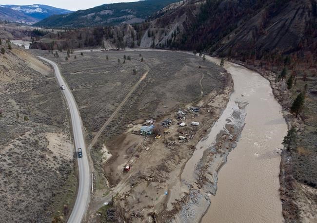
VICTORIA — A highway that washed out in more than two dozen places has reopened to the public a year after a series of atmospheric rivers stalled over southern British Columbia.
Transportation Minister Rob Fleming says it has taken crews considerable work to restore Highway 8, a scenic corridor that snakes along the Nicola River between Merritt and Spences Bridge.Â
When the heavy rains pummelled B.C., the Nicola River surged and changed course while whole sections of the highway, and some homes, fell into the waterway.Â
Residents along the highway, including members of the Nooaitch, Shackan and Cook's Ferry First Nations communities, were isolated or evacuated to other communities, many of which were also dealing with the consequences of the flooding.Â
The B.C. government says the current repairs are temporary and work is ongoing to install roadside barriers, place large rocks to stabilize the road embankments and process rock for permanent repairs.Â
There were 25 washout sites along the highway and repairs include temporary bridges spanning 73 metres and 85 metres.
"From the first day of the atmospheric river, people have gone above and beyond to help us to reach this important milestone," Fleming says in a statement.Â
"We all owe a huge debt of gratitude for the impressive work that crews and staff have done to reconnect the people and communities along Highway 8."
The highway has previously served as a detour option during closures of the Trans-Canada or Coquihalla highways. However, the government says that is not yet a suitable option while Highway 8 remains a construction zone.Â
Work also continues to restore fish habitat, and the government says more than 5,000 fish were salvaged from isolated channels and returned to the Nicola River.Â
The flooding last November destroyed transportation links across British Columbia, at one point cutting off Metro Vancouver from the rest of Canada.Â
The Coquihalla Highway, a vital artery linking B.C.'s Lower Mainland with the rest of the province, was reopened to the public in January thanks to temporary repairs.Â
The floods also caused significant damage to British Columbia's agricultural land in Abbotsford, where more than 1,100 farms were under evacuation order or alert at the peak of the disaster. About 630,000 chickens, 420 cattle and 12,000 hogs died in the floods.
On Monday, Agriculture Minister Lana Popham said most dairy and poultry farmers are "back to normal" operations and the majority of annual field crops were planted, but it's been an emotional year, and many are crossing their fingers for good weather this season.Â
This report by The Canadian Press was first published Nov. 9, 2022.
The Canadian Press


